
Canada’s Glaciers
Bugaboo Glacier. Photo by Lynn Martel.
What are glaciers?
A glacier is a body of permanent ice that has been compressed by its own weight and has begun to move under the influence of gravity. These ice masses form as snow falls and accumulates long enough to be compressed into ice, a process that can take several of years. Many factors go into shaping glaciers, and depending on the specific altitude, climate and topography where the ice is forming, a number of different types of glacial ice may take shape.
Globally, it is estimated that there are 160,000 glaciers covering around 650,000 square kilometers of terrain. Canada is home to around 20% of the world’s total glacial volume, but our glaciers in southern Canada are in rapid decline.
What is glaciology?
Simply put, glaciology is the study of frozen water. It is the scientific examination of snow and ice and their physical properties through time and space. Glaciologists research snowpacks and the formation, movement, and properties of the different kinds of glaciers, trying to determine how glaciers are impacted by the surrounding environment, and in turn, how the surrounding environment impacts them.
Canada is home to world class glaciology research centres. Peyto Glacier in Banff National Park is one of the most well monitored glaciers globally, having been named a reference glacier in 1968 for the United Nations International Hydrological Decade Research Initiative.
Glaciers can be found in mountain ranges in western and northern Canada, as well as in the high arctic. Many are concentrated in icefields (masses of interconnected glaciers in mountainous areas, typically with ridges and peaks poking through) and icecaps (masses of ice larger than icefields, swamping the land area on which they rest). Some of Canada’s icefields include:
Andrei Icefield (Northwestern BC)
Homathko Icefield (Southwestern BC)
Lillooet Icefield (Southwestern BC)
Columbia Icefield (Southern Rocky Mountains, BC and AB)
Wapta Icefield (Southern Rocky Mountains, BC and AB)
Icefield Ranges of the Saint Elias Mountains (Kluane National Park Reserve, YK)

The distribution of Canada’s glaciers. Taken from the Canadian Mountain Assessment (McDowell et al., 2023).
A video explaining water research and monitoring in the Canadian Rocky Mountains and how this helps us understand water on the Prairies, including flood and drought.

The British Columbia glacier inventory map (1985-2005). Map produced by the Western Canadian Cryosphere Network.
An Alberta glacier inventory and ice volume estimate, produced by Shawn Marshall and Eric White in 2010, can be found here.
Watch the message from Shawn Marshall, an Environment and Climate Change Canada research scientist, who spent nearly two years camping on glaciers in western Canada and the Arctic to study glacier-climate processes and glacier hydrology.
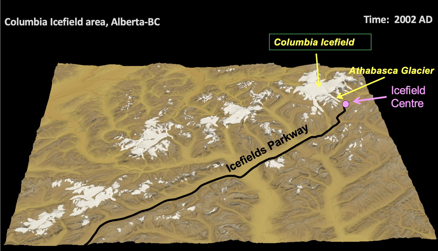
The Columbia Icefield
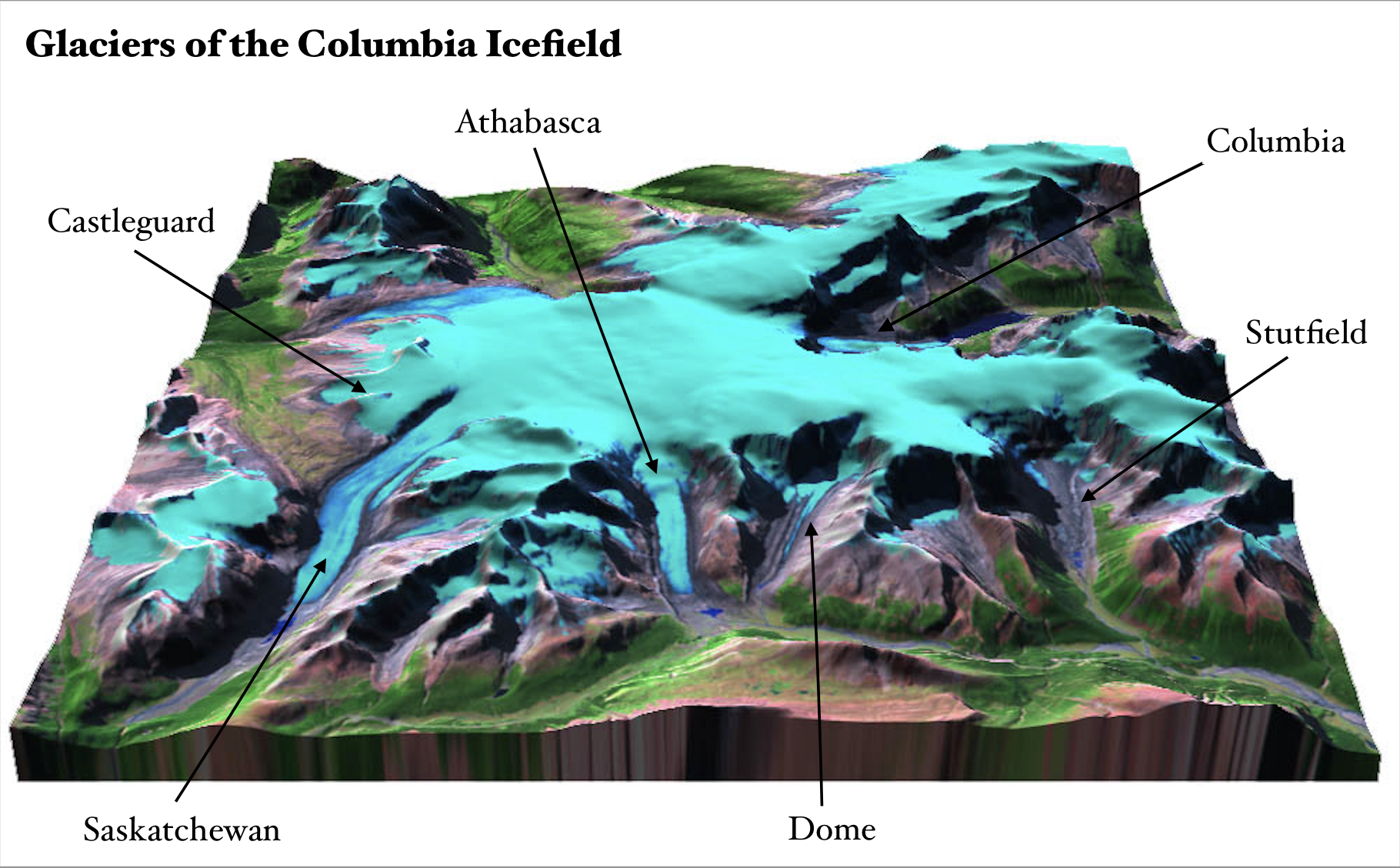
Graphics by Mike Demuth and Alex Chicagov, and Clarke et al. (2015).
Located along the Alberta-BC border, the Columbia Icefield boasts around 200 square kilometers of snow and ice. It is the largest icefield along the continental divide of North America and features a triple hydrological apex, where meltwaters flow towards three different oceans. The icefield feeds the North Saskatchewan, Columbia, Athabasca and Fraser River systems, and tourists from around the world come to marvel at the glaciers from the famous the Icefields Parkway. The Parkway offers visitors a truly unique experience at the Athabasca Glacier, where tourists are able to walk the glacier’s recession pathway up-to (and even on) its edges. The Columbia Icefield formed during the Great Glaciation (238,000 to 126,000 BCE) and is rapidly disappearing.

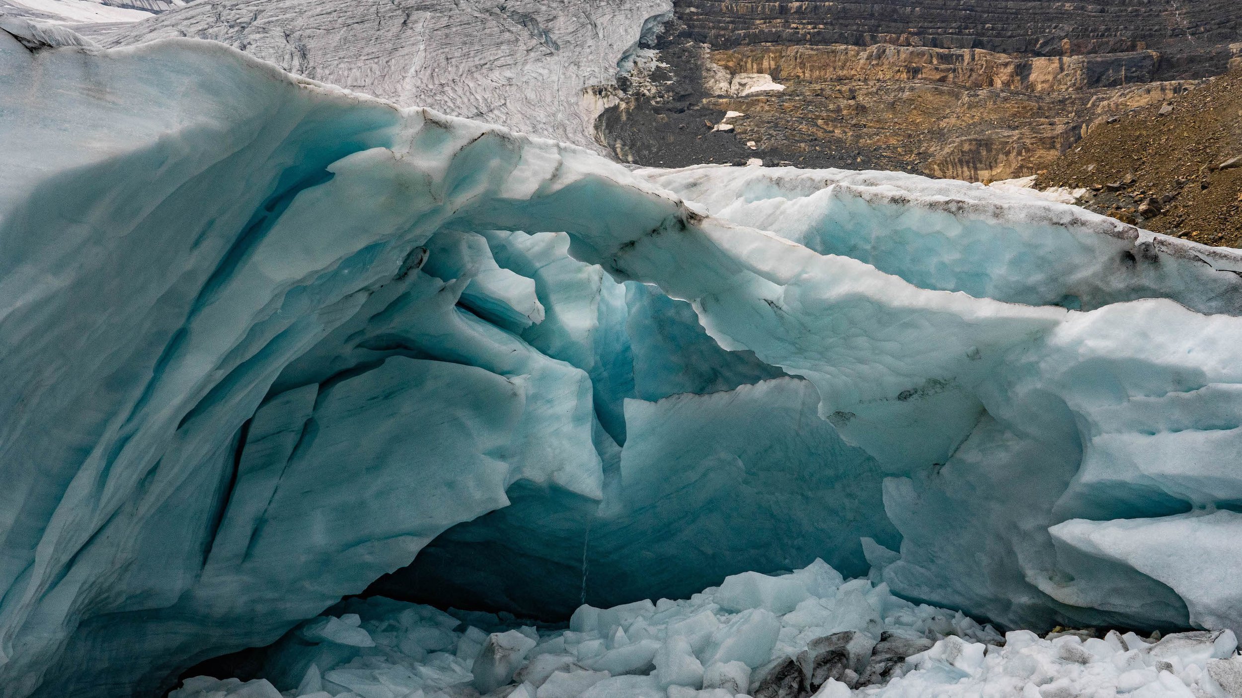
The Athabasca Glacier, 2023. Photo by Zoë Johnson.
What does “Athabasca” mean?
The word comes from the Indigenous Cree language and means “place where the reeds grow.” The name refers to the Athabasca River in the area of Lake Athabasca in northeastern Alberta. Meltwater from Athabasca Glacier creates the Sunwapta River, which joins the Athabasca downstream. The Athabasca River, too, has its origins in the Columbia Icefield, but it originates from the Columbia Glacier, which is not visible from the Icefields Parkway.
Did you know?
The area featuring Banff, Jasper, Kootenay and Yoho National Parks, as well as the Mount Robson, Mount Assiniboine and Hamber provincial parks form the UNESCO Canadian Rocky Mountains World Heritage Site. These parks have been declared of international significance because of their outstanding physical features. Here we can see fantastic examples of glacial geological processes such ice fields, remnant valley glaciers, canyons and of erosion and deposition, and the Site contains the Burgess Shale Cambrian fossil sites containing important information about earth’s evolution.
MacArthur Glacier, Yoho National Park. Photo by Lynn Martel.